
In a bold push to address one of Delhi’s most persistent civic issues — traffic congestion — the Delhi government is exploring the construction of an elevated corridor directly above the existing Ring Road. The stretch under consideration spans some of the most gridlocked parts of the city, particularly from Ashram Chowk to Bhairon Marg, where daily traffic snarls have become the norm despite existing flyovers, Metro corridors, and traffic diversions.
The plan is currently in its feasibility study phase, initiated by the Public Works Department (PWD), and is seen as a strategic move to unlock smoother east-west and north-south connectivity within the capital.
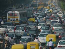
The Ring Road is one of Delhi’s most critical arteries — a 40-km-long loop that connects major zones across the city. However, as vehicle numbers continue to grow exponentially, several stretches of this loop have become notorious for long queues, poor traffic flow, and unpredictable travel times.
Key congestion hotspots on the Ring Road include:
Despite the presence of multiple flyovers and traffic management efforts, these bottlenecks remain unresolved due to:
The elevated corridor is being seen as a solution that allows for grade-separated movement, meaning vehicles won’t need to stop at intersections, signals, or deal with merging traffic. By constructing the road above the existing Ring Road, the project aims to utilize vertical space without requiring additional land acquisition — a key hurdle in densely built-up urban areas.
While final alignments are yet to be determined, the Ashram to Bhairon Marg stretch has been prioritized due to:
This proposed corridor would effectively complement (not conflict with) existing infrastructure like the Barapullah Elevated Road, which serves east-west traffic but doesn’t fully cater to Ring Road congestion due to its limited coverage.
The Delhi PWD is currently engaging consultants to assess the technical, environmental, and financial feasibility of the project. Areas under assessment include:
A major advantage cited by PWD officials is the plan’s minimal requirement for land acquisition, making it politically and socially more viable than horizontal road expansion.
If executed, the elevated Ring Road could form part of a larger vision for tiered urban mobility in Delhi — similar to models seen in cities like Bangkok, Shanghai, and Dubai, where ground-level, elevated, and metro corridors work in tandem.
Benefits include:
It also complements other mobility projects such as:
The project is currently not yet approved for execution, but detailed planning is underway. If approved:
The Delhi government is reportedly working in coordination with the Delhi Traffic Police, DMRC, and Central Road Research Institute (CRRI) to ensure that this corridor integrates smoothly with existing systems.
While an elevated road may reduce emissions from idling traffic, construction itself will involve dust, noise, and temporary disruptions. The feasibility study will include an Environmental Impact Assessment (EIA) covering:
Given that the Ring Road passes close to several ecologically and historically sensitive zones, including the Delhi Zoo and Purana Qila, clearances from agencies such as the National Monuments Authority may also be required.
Delhi’s proposed elevated corridor above the Ring Road is more than just a road project — it represents a paradigm shift in how the city tackles mobility. As surface-level congestion becomes harder to address, vertical infrastructure may become a necessity rather than a choice.
If the feasibility study returns positive outcomes, the project could become a template for similar elevated solutions elsewhere in Delhi-NCR — from outer ring roads to satellite towns.
The plan is still evolving, but one thing is clear: Delhi is getting serious about long-term, structural traffic solutions. The success of this project could determine how India’s capital reinvents its transportation landscape for the coming decades.
1. Why is Delhi planning an elevated road over Ring Road?
The plan aims to reduce chronic traffic congestion on some of the busiest stretches of Ring Road, especially between Ashram Chowk and Bhairon Marg. Despite existing flyovers, the area experiences severe bottlenecks. The elevated road is expected to enable signal-free, uninterrupted traffic flow without requiring additional land acquisition.
2. What is the proposed route for the elevated corridor?
The initial route under study is from Ashram Chowk to Bhairon Marg, covering key intersections like Sarai Kale Khan, near Nizamuddin Railway Station, and Pragati Maidan. This corridor connects South and Central Delhi, making it a crucial segment for decongestion.
3. Has the project been approved?
As of now, the project is in the feasibility study stage, led by the Delhi PWD. No final approval or budget allocation has been made yet. The study will assess technical, environmental, and economic viability.
4. Will construction cause traffic disruptions?
Yes, but likely in phases to minimize disruption. PWD will coordinate with Delhi Traffic Police and use smart management tools to reduce inconvenience during execution.
5. How will this project benefit commuters?
Benefits include:
6. How does this fit into Delhi’s larger transport plan?
The elevated road will complement other infrastructure like:
7. What environmental checks will be in place?
The project will undergo an Environmental Impact Assessment (EIA) covering air quality, tree preservation, construction dust management, and noise reduction. Agencies like the National Monuments Authority may also weigh in, given the proximity to heritage zones.
8. Will public transport benefit from this project?
Yes, indirectly. By decongesting the Ring Road, buses, ambulances, and feeder systems can move more efficiently. While not dedicated to public transport, the corridor reduces road burden and improves overall traffic flow.
9. How long will the project take to complete once approved?
If approved, construction could begin within 18–24 months. The timeline for completion would likely be 2–3 years, depending on execution phases and technical complexity.
10. Is land acquisition needed for the elevated corridor?
No major land acquisition is expected, as the elevated road will be built directly above the existing Ring Road, utilizing vertical space and avoiding the legal delays tied to acquiring built-up land.
Part of the NCR Guide editorial team, covering news, real estate, food and lifestyle across Delhi NCR.
Join thousands of Delhi NCR residents who start their day with our morning brief — top stories, real estate updates, events and deals.